View 86 Photos
Solo Hiking Picos De Europa in 10 days
In June 2022 I solo hiked 100km+ through Picos the Europa National Park. It was my first time I ever did such a solo hike, as was it my first time documenting it like this. Each night I either went wildcamping in my tent or slept in a refugio (mountain hut). On my YouTube channel you can find the video about this trip.
Hike
Download GPX
Hike
Download GPX
Day 1
This morning I took a bus from Bilbao to Santander (last night I arrived by plane from Amsterdam). In Santander there was a 90 minutes layover before the bus to Potes left. Those 90 minutes were crucial, as it was the timeframe for me to get a gas canister. The only, must have, piece of gear I still needed for the hike (as you probably know, you can't take gas canisters with you on the plane).
When I arrived in Santander, my complete focus was on getting this gas canister. There were two options for me to get my hands on this;
- Grab a 15 minute taxi to and from Decathlon to buy it
- Search around the bus station for a shop
Option 2 was preferred, as I didn't have to pay for a taxi, and it would take me less time. As the shops were about to open, I went for option 2. Then the question came, where do you buy such a thing? I guess you can't buy it in a regular supermarket, or can you? Most chances are you need to find some kind of specialty shop that sells tools/outdoor stuff etc. After I wandered around for a bit I could not find any shop that could possibly have it. I walked towards a taxi driver to ask for a ride to Decathlon. But, before I asked him this, I asked if he knew a shop that might sell gas canisters. He knew, he pointed to this shop that was literally across the road from the bus station!
When I walked up to it I saw it was a hardware store. Some closer investigation, through the windows of the shop, gave me a glimpse of gas canisters. As the shop was about to open I kept an eye on the entrance. When the shopkeeper was opening the door, I asked straight away for the gas canister and he told me to go inside with him. He grabbed it, I tested it to make sure it was the right fit (some gas canisters don't have the right thread that fits your stove) and I bought it. Now I was 100% ready for my trip.
An hour or so after my gas canister experience I went on the bus to Potes. Once in Potes I needed to find a way towards Fuente Dé. According to a strange website, there was a bus running, once a day, between Potes and Fuente Dé. But, according to the bus driver, there was no bus... Eventually fellow travellers in the bus also needed to go to Fuente Dé, so we decided to share a taxi. Once in Fuente Dé, I took the gondel up and the hike was on!
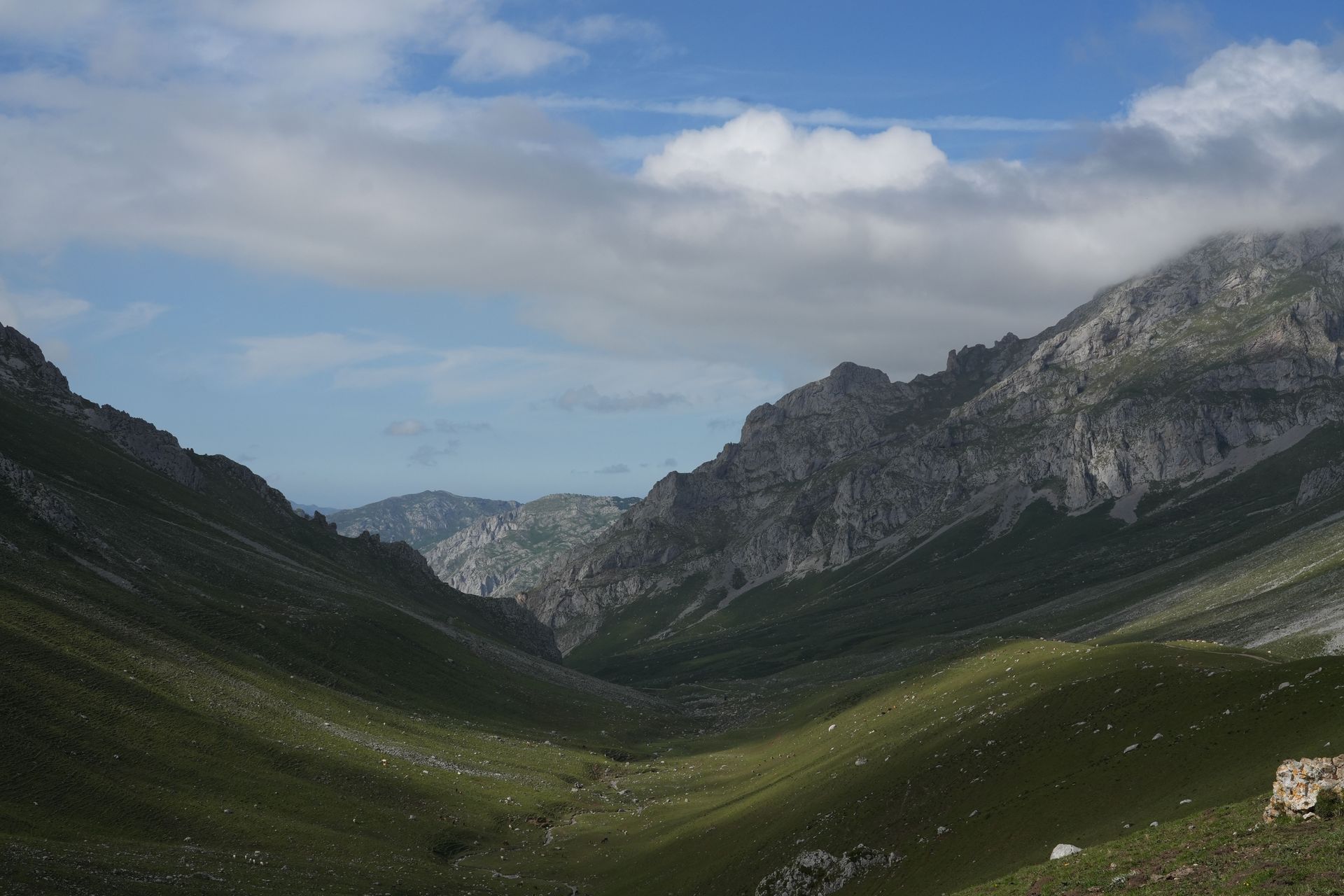
In the beginning there were still a lot of people around me. Mainly day tourists that take the gondel up and down. As soon as I started my way further away from the gondel area, the fewer people there were. Now when I looked I didn't see people, but stunning mountain peaks. When I didn't look at the peaks, I saw cows, sheep and horses. Besides those three animals, there were these big dogs. I'm guessing they protect the sheep from predators. I came across a few of those dogs, and despite their big and sturdy appearance, they acted friendly. They either didn't care or wanted food from you. Apart from one dog...
I don't know why, but I was walking gently past some sheep when out of nowhere this big dog appeared. Running, barking and showing his teeth at me. As I'm quite familiar with dogs, I knew this wasn't a good situation to be in. I straight away ran backwards while simultaneously spreading my arms (with my hiking poles) and screaming louder then he could bark. This seemed to stop him, but he kept a close eye on me.
As I needed to continue the track, and taking a different track would take me an extra 30 min, I tried to loop around the dog. This didn't work and the barking and screaming all happened again. The only thing I could do was take this 30min detour, which managed to get me across safely.
At the start of the hike, it was already 15.30. So it didn't take long before I made myself dinner followed by looking for a spot for the night. Just five minutes off the track there were these high rock formations. I walked towards it and found an overhanging rock area that gave me a nice shelter. Here I set up my tent and spent the first, solo, night outdoors!


+3
Hike
Download GPX
Day 2
Oh my, what a day it has been...
I woke up with no problems. Had left over rice for breakfast, packed everything up and headed out. The goal was to follow the (dried up) river upstream, until I reached the starting point of the river. Then a little scramble to get up the final piece of the mountain, followed by a mountain hike towards Andarra. To cut to the chase; I never reached the top of that first mountain.
It all began with not having a way of navigating. My map skills simply aren't great. The thing was that on the map it looked like the track was in the river. However, the track actually was (as I would find out later) 30m next to it. And not simply 30m next to it, no, high up on a cliff that followed the river. This explained why I had such a hard time moving forwards going through this river. It was a hard scramble to move up, often climbing on my hands and feet. Once it seemed I had reached the top of the river, I faced massive vertical rock walls. No way I could climb up on these.
The original track would lead you to this small passway that allowed you to reach the top. Even Though I was close, I couldn't find it. Everywhere I went was a vertical wall going up, or, a steep cliff going down. To make matters worse, I was inside the clouds meaning I did not see much.
After I had searched around I realised four hours had gone past and time was running out. It was now twelve o'clock and I had to make a decision. Either keep looking for this passway, or track back to where I started. I continued looking for like half an hour, with no luck. I now made the decision to track back. However, tracking back wasn't so easy anymore.
In searching around for that half an hour, I had wandered off track even more (as I basically had done since the beginning of the day). I tried to go down slowly, constantly adjusting my course as high cliffs would appear out of nowhere (the clouds limited my visibility). What made it worse; at a certain moment I realised I lost my tripod. This I have hanging on the side of my backpack for quick access. It made me happy there was some luck that day, it only took me a 10min scramble back up to find it laying on the ground. At this point I felt quite down.
Fortunately I had found the tripod, but not on my way back. I did see the river I initially walked up on, but was separated by steep cliffs. After a slow scramble down I managed to reach the river. Now my logic was to simply follow it until I reached my starting point of the day.
Something I forgot to mention was the surface of the ground I was walking on. It was this layer of small stones making it uneven and loose. Each step was a possible slip.
Eventually I reached the river and not long after that what I had been looking for the whole day: the track. Now I meticulously followed this path down. What had taken me four hours in the morning to go up, took me two hours to go down using this path. Once I saw a road with people I almost became emotional...
By now it was four o'clock and I really didn't fancy sleeping in the same spot again. Looking on the map I found a refugio (mountain huts) and headed towards it.
At 1322m I found refugio De La Teranosa. Located in mountainous hills with views of grazing cows. A refugio that has room for 20 people. I've just had my dinner and cleaned myself with a cloth, as far as that's possible. Now I'm chilled out on the bed.
I will sleep well tonight...


+3
Hike
Download GPX
Day 3
It's been a(nother) tough day. Today I hiked 15km which took me a good 7 hours. Even though I slept well last night, in the refugio, my body is still asking for recovery. On a side note; I slept with like 15 people in one open area, and not a single person snorred! Well, unless I was that person, then I'm sorry for the others.
As I was saying, my body asked for a recovery day. Which is difficult considering you are on a daily schedule of hiking through the mountains. The only thing I could do was make the day shorter. Hence I'm in my tent at 5pm.
Nonetheless it was a day with stunning views. As someone coming from the flat Netherlands, those mountain views never get boring.
The highlight of the day was passing through refugio de Urriella. This was at today's half way point and allowed me to have an extensive lunch. So much so that I don't fancy dinner tonight. Actually, I over ate myself and had stomach problems the whole afternoon. Only me to blame for this.
If I may choose a second highlight of today, it would be coming across patches of snow. Some patches even needed to be crossed as they were the only way to continue the track. I don't have any crampons for my shoes (spikes you put under your shoes), so I made careful steps and good use of my hiking poles.
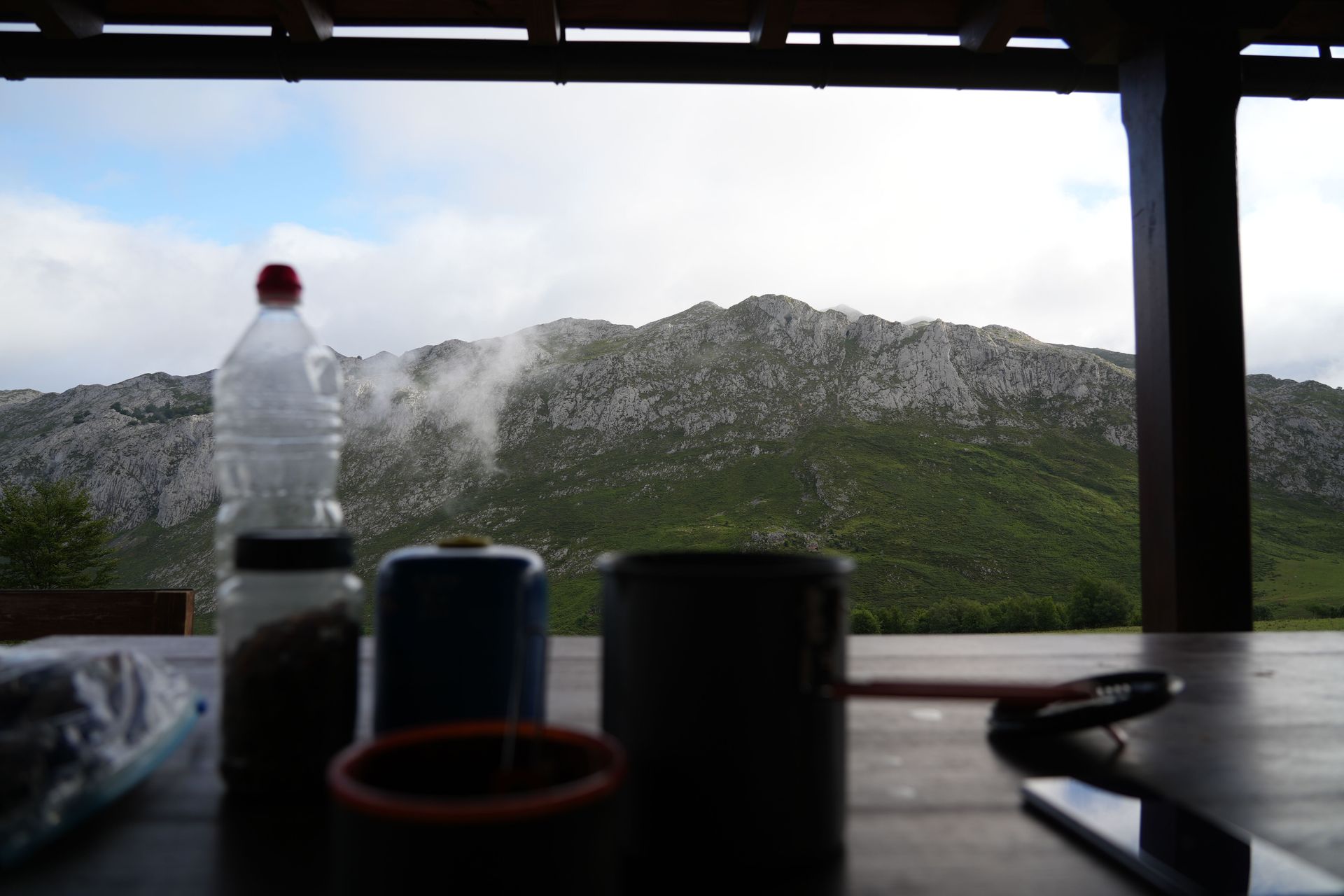
As said, I'm now in my tent. I've set it up next to refugio Jou de los Cabronas. A very remote refugio that is only accessible by two sides. Two sides that require you either walk up a metal ladder they built in the rock wall. Or, via the other side with a rope to pull yourself up over a cliff. You can imagine this makes it hard for the refugio to get supplies. Which is why they get supplies by air. At the back of the refugio there is a helicopter landing zone. That's how remote it is here.
Now I'm going for a power nap and might grab a sandwich and tea in the refugio this evening.


+4
Hike
Download GPX
Day 4
And day four has come to an end. At the time of writing this I'm having a full plate of pasta. Precisely what I needed after a day of hiking.
How yesterday was all about going up, today was all about going down. It of course takes less effort to go down, which allowed me to make significantly more kilometres. Besides this, the last four hours were along a relatively flat track following the river. To give you the facts, yesterday I managed 15km in 7 hours. Today I did 30km in 10 hours.
You can imagine these long days, without adequate recovery, are beginning to take a toll on my body. Each night my legs have been "singing". Meaning you can feel your muscles are restoring itself. Back home I have this after a hard workout session. Guess these hiking days qualify as hard workout sessions.
To at least help the recovery process in some way, I'm putting great effort into allowing my body to wake up when it does (so no alarm). And, eat every calorie that I can get my hands on. If this means I get vegetarian dishes instead of vegan dishes, so be it. You can't expect to get your vegan-soya-bean-curry in these remote places.
What did I do today? Well, I woke up in my tent and started to head my way down. It began with a rough mountainous section using a rope going down. After this it was an "easy" stroll down. Through grasslands, bushes and cows.
This continued until I reached the village Bulnes. Here I got myself a patata braves (loaded fries) with a cola, before going down even more. The going down stopped when I reached the river. Following the river, I had a section that took four hours on a well maintained track. A track many people use as a nice day hike.
Eventually I reached the next town, Caín. Here I've set up my tent in a centrally located piece of land, next to a river. The river I will use soon as a shower after I've finished my plate of pasta. My first shower in four days!


+6
Hike
Download GPX
Day 5
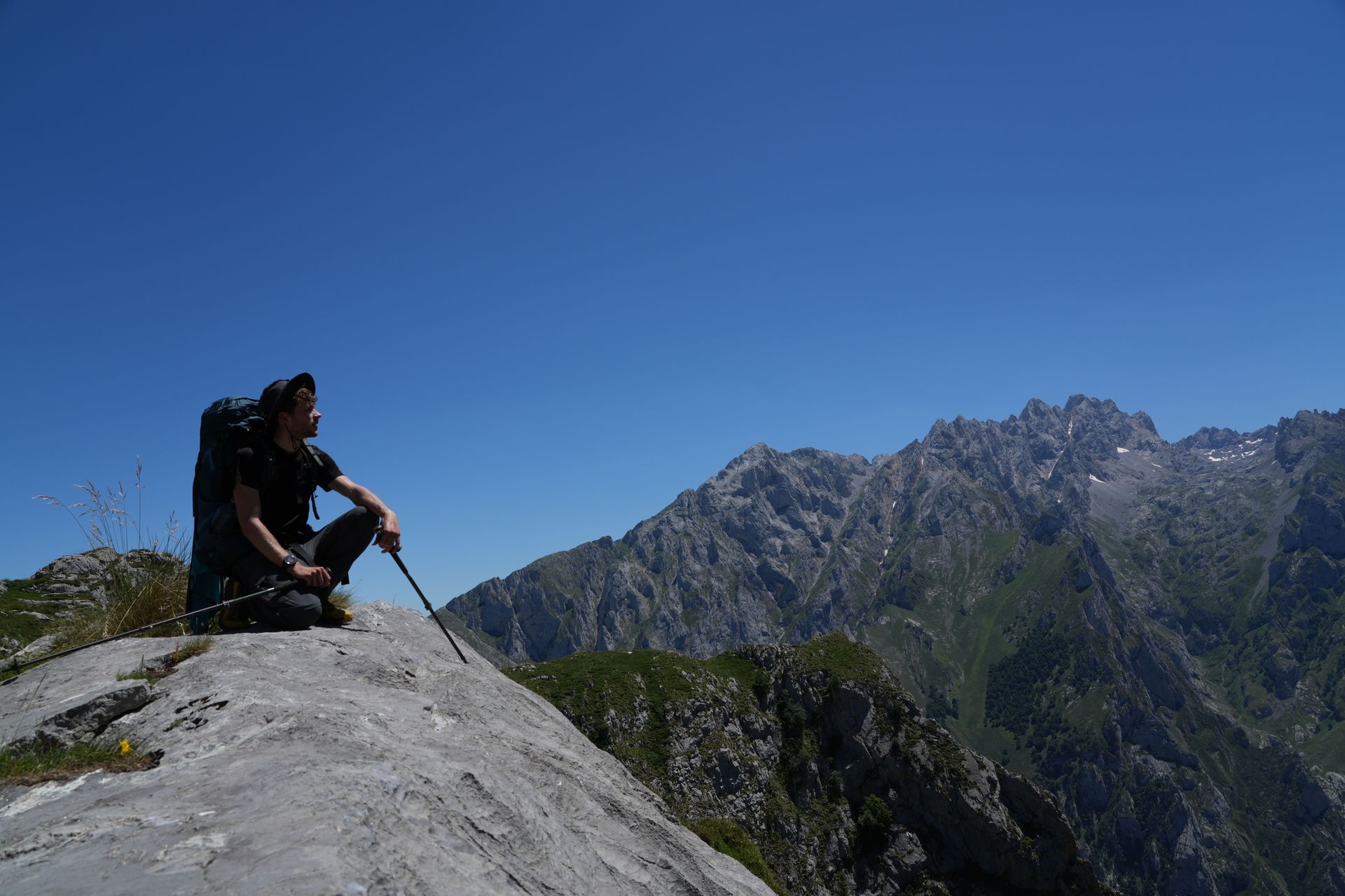
Kept it short today. Nevertheless, it was not by definition also easy. I think I had the toughest climb of my life. In 1.5km horizontal distance, I made 450m vertical metres. Taking me over three hours to complete, in the blazing sun.
Fortunately I came across some other people on the trail, giving me motivation to keep pushing. Even these two Spanish guys I've been crossing paths with for the last two days. As a nice gesture I've taken some pictures of them that I'll send them via email once I'm back home.
When the climb reached its top it was an easy section going to refugio Vega de Ario. A busy refugio that acts as a pitstop for many day hikers. I decided to pitch my tent here. The two Spanish guys headed on saying they wanted to cover more distance today as there is a forecasted thunderstorm tomorrow afternoon. I'm taking the risk that I'll be able to do that section tomorrow before the storm arrives.
As a side note, some people may wonder how you do your number-two out on the track. Each day I can choose one of two options. If I'm lucky I can do my number two in a refugio, in the compost toilets. These let people do their business in an environmentally clean manner without impacting the surrounding area in a bad way. You only have to separate the toilet paper by throwing it in a bin next to the toilet, as this doesn't decompose. When I'm unlucky, I need to do my business while out and about. When this occurs I find myself a secure spot, away from the main track, and any water source. I dig a little hole with my spade. Then the fun part starts, I need to aim for this hole! When I succeed I throw dirt over my piece of art. The toilet paper I put in a hermetically sealed off bag, stored down in its own section, in the bottom of my bag. Ready to throw away at the first possible bin. So you know, at refugios you don't have the possibility to throw away your garbage. It comes down to the fact that everything is expensive to transport to and from refugios. This means people need to take their own trash and throw it away in the nearest village.
Now I'm preparing to get a "proper" shower. Not like in the freezing cold river as yesterday. But, using this decathlon, water compressed, bottle. It even has warm water as the people from the refugio have let the bottle be warmed up in the sun!


+3
Hike
Download GPX
Day 6
Day 6 and I hiked 6 hours. 6 hours of hiking would sound like a long day if you asked me before this trip. However, compared to the other days, which were 7+ hours each day, today was a short one.
I didn't mind today being short. It was kind of planned like this. As said, people yesterday were talking about a possible thunderstorm. They were right. Momentarily it's 15:40 and you hear the occasional thunder. Fortunately, far away from us.
Actually, I already heard some thunder when I was going down during the last section. Normally I'm not scared of thunder. But, being high up in the mountains makes it a different story. Let's say I'm happy to be inside the refugio, warm and safe.
As you know the weather now, you probably find it hard to believe that during the hike I needed to put sunscreen on. But let's go back a step.
Yesterday I had this fierce climb in the blazing sun with it being 30 degrees. This morning I woke up in the tent surrounded by clouds. Meaning everything was damp, if not soaked. A wet tent was packed and the hike started. During the hike I quickly emerged above the clouds. And what is the weather above the clouds? You guessed it right, sunny! From a cold 10 degrees in the morning, it became 25 when I felt that sun on my face. This lasted until I started the descent down, back into the clouds. Having now the same conditions as in the morning, but with the occasional thunder. You really can get all types of weather in a single day here.
This works two ways of course. It means it can clear up soon, or become worse in a short amount of time. Maybe the most challenging is when you find yourself inside the clouds. This severely limits your visibility making it hard to navigate. Besides my lack of experience in navigating (which we saw the second day), this limited visibility has resulted in me going into the wrong direction a few times. Today I even made a mistake that took me half an hour to correct.
Nonetheless, I do feel I've improved in my ability to 'read the trail'. You are constantly on the lookout for signs that confirm you are going in the right direction. This could be a well walked dirt track that clearly has been used by people (and in many cases also by cows). Especially if you spot these little holes made by hiking poles, you know you are on a known track. Next to that, some of the well maintained tracks have paint patches that mark the trail. If that isn't enough, you have my favourite kind of sign, the 'trail heads'. For those who don't know; they are little man-made pyramids of stones. Some sections might have them every 10m, which definitely helped me during those times when visibility is limited.
Those trail heads made me arrive at today's refugio just in time before the storm. Now it's chill modus activated and enjoying some relaxing time.


Hike
Download GPX
Day 7
It was one of those days where everything seemed to be in my favour. Let's start at the beginning.
This morning there was an early breakfast as I'd planned a long day ahead. Seven o'clock we were served breakfast. Yes, I mean "we". This Spanish father and his son also slept in the refugio last night. After some chit chat with them I got to know they are from Bilbao and on this annual father-son trip. Each year they go out to the Picos, visit a different refugio and do day hikes. After breakfast we went our own way to prepare for today's hike.
Today's hike started with a fierce climb that took us about two hours. Again I'm using "us" here, as the three of us were heading into the same direction. Once we reached the top, they headed back and I continued through the mountains. It was nice to not be by myself for a change.
During the climb the weather had improved. At the top of the mountain we were above the clouds. And so, my jacket was swapped for a hat and sunscreen. As the majority of the hike was above 2000m+, the clouds remained below me. Which also resulted in stunning views.
Next to seeing mountain peaks in the distance, there were a few peaks close by. The hike today required me to either summit, or bypass them. You feel really small next to those immense bodies of rocks.
At around the halfway mark, being still high up in the mountains, I came across this campground. It had several prepared patches of grass, where you could pitch your tent. If the weather wouldn't allow you to pitch a tent, you could make use of the stone hut. Which had bunk beds that fit six people. If I ever return to Picos, I will definitely camp here for a night.
After the mountainous section it was time to head back down. A steep section that brought you straight into the clouds. Fortunately the clouds never really reached me, as I was walking now through a forest section, under the trees. In this forest I came across streams and a not working water tap.
As a hiker you are careful with your water. Especially during the sections where you know it's going to be hot, physically demanding and no water sources along the trail. Luckily, the map showed water taps. But as you saw, that water tap I came across in the forest didn't work. A few times it also happened to me that I either couldn't find the water tap, or it didn't exist. That's why I make sure on the trail to never finish my water completely, as you never know if a situation arises where you depend on it. Anyway, eventually I reached refugio Vegabano, after a day of 11 hours and 20km. But my adventure didn't stop here.
Although it was a small refugio, it had a buzzing atmosphere. Some kids were riding donkeys, some adults were drinking beer and at the back of the refugio there was this small farm. The farm had a vegetable garden and chickens running around. The guy who worked at the refugio approached me and I told him I wanted to stay the night. I only wanted to sleep, and not have dinner/breakfast. The reason being I was running low on cash. I had underestimated the amount I would be using on this trip. Not having to pay for food was ok as I'd have precisely one portion left for dinner/breakfast. And, tomorrow I would reach a village for resupplies. When I told the guy I only wanted to sleep, and had my own food, he explained to me a different option for the night.
Just a 20min walk from the refugio, at the top of a hill, there was a little cabin called Pico Jario. A cabin for one person with firewood to light a fire. When he said that last thing, he didn't need to convince me anymore. I was heading to Pico Jario!
As I'm writing this, I'm laying on the mattress, with a fire burning next to me. I've had my dinner and some chocolate + tea as dessert. While preparing dinner I managed to hang up my tent to let it dry by the fire. Even though Pico Jario fits one person, I can't say I'm alone. A few minutes ago I got visited by the local cows. They gave me some weird faces, but they let me stay in the cabin.
Now it's about to hit bedtime. I will clean up some stuff, brush my teeth and sleep for my first night ever in a cabin.


+1
Hike
Download GPX
Day 8
Walking on a calorie deficit is definitely not the case anymore. The last two days I had limited access to food, meaning I had to ration what was left. Right now, in refugio Collado Jermosa, that is not the case anymore. I just had the opportunity to stuff myself full. Two plates of pasta (I asked for a second one), one of potatoes with falafel and some custard as dessert.
What I find strange is that it's difficult to get supplies to the refugio's. Which is why you would think they are conservative with the portions they serve you. It couldn't be further from the truth. Each refugio I went to, they gave me big loafs of bread, containing big pieces of cheese, for lunch. For dinner you get served so much most people don't eat it all. Strangely enough this doesn't happen with breakfast. Breakfast is standard and basically boils down to a plain piece of bread with coffee. Guess it's to balance it out as you are still full from last night's dinner.
Going back to the refugio I'm staying in now; It's located at 2067m, in some areas here you have cellular service and you can pay by card. The first one I've come across that lets you pay by card. If you can remember, this suits me perfectly as I was running low on cash. Great timing.
Paying for the night was never an issue, as I've set up my tent 50m from the refugio. That's an option you often have at refugio's. When you visit refugio's you can either choose to pay and sleep inside, or, set up your tent nearby, for free. I feel it's the perfect fit to set your tent up next to a refugio and make use of the food they serve.
Let me get to how my day went. It was another long one. I woke up in the beautiful cabin, made myself breakfast and packed everything up. The plan was to stay the night in Posada de Valdeon, a little mountain village. It took me just a few hours to reach. The first half of the hike was very damp and muddy. This was because of the forest section in combination with low hanging clouds. The second half was an easy walk over a dirt road, along a river.
Once I arrived in Posada de Valdeon, my objective was to find somewhere to sleep. I was planning to treat myself well by sleeping in a hostel. Fate did not allow me to do this. I asked six different accommodations, all were fully booked or closed. What to do now?
I decided to get resupplies in the local supermarket (a one room shop containing basic things like; canned food, cookies, ice cream etc.). Sitting on a bench, eating freshly bought bread and cookies, I thought about what to do for the night. I had two options;
- Walk to a campground four km away from the village
- Continue the hike to refugio Collado Jermosa, a four hour hike, containing a 1100m climb.
As it was only halfway through the afternoon, I decided to head towards refugio Collado Jermosa. Initially the plan was to do this section tomorrow, but yeah, plans change all the time during vacation.
In the end I didn't find the climb that difficult. Maybe it's because I'm getting used to them, or it just wasn't that hard. Probably a combination of both. The information sign said the climb took four hours. Me having a heavy backpack (as I had bought resupplies) and filming along the way, was aiming to do it in five. Somehow I managed it in less than three hours. Even though the climb was relatively easy, along the way I came across one dangerous situation...
At a certain point when going up, in the foggy clouds, I heard people shout in the distance, up above me. I waited a minute to see if I could spot them. Then, suddenly out of nowhere I heard the most dangerous noise on a mountain; that of rocks rumbling down. Because of the big bangs, you knew it was a lot, containing big ones. I saw rocks going down at full speed, just 10m away from me. Going down where I would have been walking if I had not waited that minute. I screamed up. Letting the people above me know I was down here. They yelled if I was ok, and I said yes. It didn't take long before they emerged out of the clouds, a group of 30 French students. I let them know they were acting irresponsible and that there were other people below me. This moment made me realise again how vulnerable you are in the mountains. Sometimes things can happen that are out of your control.
Talking about those people below me; they were a young Spanish couple going up to the same refugio, for a multi day hike. I took pictures of them and promised to send them the photos. At this point I have four email addresses of people that I need to send photos. I like to make pictures of other people going up, as that is something I would have liked. You get angles you never can take yourself. And, get some nice small talk.
After that dangerous situation I reached the refugio. Here I ordered a beer to enjoy the nice views. I don't know why, maybe because I'm sensitive to alcohol, maybe because I just had done something physically demanding, or the altitude made it happen; that single beer was enough to make me tipsy!
Momentarily I'm settling down from the big diner we got served. Everyone around me has been talking about the sunset that is happening soon. So, you know what I'm going to do now.


+2
Hike
Download GPX
Day 9
Kind of having a sad feeling this trip is coming to an end. What an adventure it has been. Encountered many situations that brought me out of my comfort zone. Picos will always be my first and have a special place in my heart.
Today I've met interesting people. During breakfast I sat beside this couple from Ireland, during dinner I shared the food with a family from the UK and this afternoon/evening I spent time chatting with Clark, who is from the US. All with one thing in common, a love for hiking. While talking with them, they gave me nice recommendations, and inspiration, for a possible next hiking trip. Who knows where that will be.
Besides talking to those people, it was my last full day in the Picos. As time would allow it, I didn't have to hike to a new spot today. Which meant I stayed put and made the most of my day. After breakfast I did some writing and had a chat with one of the people working in the refugio. I was interested to know how it worked with them being here all the time. He told me they work in shifts; two weeks here in the refugio, then two weeks free. In addition to that, he told me that this particular refugio is only open during the summer. However, during the winter they aren't completely closed off, there is simply no staff and they close off a certain section of the refugio. This means that if you are a winter climber, you would be able to come inside and sleep under a roof. Maybe an idea for a winter trip?
Anyway, during the chit chat he told me I could climb this mountain near here. Torre de la Palanca. A "simple" 90min climb to 2603m. It took me about twice as long as I had the time and wanted to take it easy. The scenery up there was stunning because of the 360° view. I ate chips and nuts at this magical place and headed back down. Back down where things had changed at the refugio.
When I left in the morning to go up the mountain, I was the last hiker to leave the refugio. This definitely was not the case when I returned. Already going down I came across a tour group of ten people. This was nothing compared to the group I saw coming down in the distance. As you can see in the photo, it made me think of that (in)famous picture of Mount Everest where you see all those people waiting in line to summit the top. This was a school group of children that, as I would find out later, all would sleep around the refugio.
It's kind of typical for the area I'm in now these last two days. I'm definitely in the more accessible area of the park as I've come across many more people. Besides that, and it's probably a reason for coming across more people, the tracks here are more accessible. Part of me doesn't really like this, as I enjoyed the rough parts of Picos the most. But, as said in the beginning, I've run across interesting people, which is nice.
Something I completely forgot to mention; the sunset of last night. It was out of this world. For like two hours I didn't know where to look, or where to point my camera. An unbelievably good view we had up here. Now on the second night at this refugio, we again went up the hill to enjoy the sunset. Unfortunately the clouds didn't disappear while the sun was setting. They disappeared after the sun was behind the mountains. Luckily this still gave us nice moments to capture.
At the moment of writing this I'm all snug up in my sleeping bag. Possibly for the last time on this trip. There is a chance I will be able to pitch my tent in Fuente Dé, where I'm hoping to end the day tomorrow. Time will tell what happens.


+7
Hike
Download GPX
Day 10
This was my last day in the Picos. Already I'm missing it. That's of course a good sign. If you miss something, you definitely enjoyed it.
I suppose the real time for reflection on this trip will come later, once I'm back in the Netherlands. Right now I've set up my tent one last time, in Fuente Dé. Where I started 10 days ago.
This final day I made my way from refugio Collado Jermosa to, as said, Fuente Dé. To give myself a treat, I took the gondel down. A final goodbye leaving the mountains.
The hike itself today was not super technical, especially the second half of the hike. This could be done by any ordinary person. And so it was done, I saw many day hikers, some in their regular clothes. Quite the contrast compared to where I've been on this trip.
Do you want to know what I'll miss most about this trip? That you are outside the whole day, doing something physically demanding and adventurous. It's this lifestyle of physical exercises, treating your body well and respecting the nature surrounding you. There were a few times I came across some hiking guides. Who knows it might have given me an idea...
Gear wise I can be happy I didn't miss something important. It all worked out well and nothing got lost (I did come close to losing my tripod). Nevertheless, I've written in my journal a list with feedback. The photo is just to visually see it, I am not expecting you to be able to read my handwriting :) Some points;
- Two pairs of socks is ok --> socks get dirty and sweaty each day. Clean pair for the night, dirty for during the day.
- Better cable management so all my electronic devices can be charged at the same time. Important for when you want to charge as efficiently as possible, quickly.
- Always pay with card if it's possible, use cash as a last resort.
- Have tea in the evening. It's a nice way to kill time.
- Chocolate, nuts and chips are great (vegan) snacks (and high in calories) for during the hike.
- I didn't need to bring a big towel. Two cloths (one for the dishes, one for the body) is enough.
Then the most important one: never go off trail. If you think you can take a shortcut, you are wrong, you can't. It's never quicker than sticking to the trail. The trail is like this for a reason. If there would have been a quicker way, that would have been the trail. I learned this the hard way.
For the data nerds among us, a list of figures;
- Total days hiking: 10
- Total distance hiked: 142km
- Hours on my feet: 79 hours (including breaks and filming)
- Nights in tent: 6
- Nights in refugio: 2
- Nights in hut: 1
- Average steps per day: 20,200
- Shortest day: 4.5 hours
- Longest day: 11 hours
With that I have many more things I would have done differently. That doesn't say this trip is a failure. Far from it. I would call it a great success and the start of something bigger. Can't express what that means, I only know a spark has been ignited. And if a spark ignites, it doesn't take long to become a fire...


+4